
Mapping the Invisible: The Physics of Multi-Directional Underground Locating
Beneath the paved surfaces of our cities lies a complex, invisible infrastructure—a tangled web of pipes and cables that function as the nervous system of modern life. For excavation professionals and plumbers, navigating this subterranean maze is a high-stakes endeavor where a single inch of error can lead to catastrophic utility strikes.
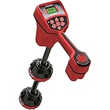
The challenge of locating is not merely detection; it is interpretation. Conventional tools have long relied on simple signal strength, forcing operators to act as human dowsing rods, sweeping back and forth to guess the center point. The RIDGID NaviTrack Scout represents a fundamental shift in this methodology. By replacing 1D signal strength with Multi-Directional Antenna Technology, it transforms the abstract physics of electromagnetic fields into a readable, geometric map. To master this tool, we must first understand the invisible forces it is designed to decode.

The Geometry of the Signal: Solving the Dipole Field
When a locating transmitter—specifically a Sonde (a small beacon probe)—is pushed into a non-conductive pipe like PVC or concrete, it emits a signal. However, this signal does not radiate in a perfect sphere. It forms a Dipole Field, identical in shape to the magnetic field of the Earth.
This shape creates a complex geometry consisting of:
* Two Poles: Points at the front and rear of the sonde where magnetic field lines are vertical.
* The Equator: The center plane directly over the sonde where field lines are horizontal.
The Problem with “Nulls”
Traditional single-antenna locators are notoriously difficult to use because they often rely on “Null” (silence) to find the signal, or they create “Ghost Peaks” (false positives) caused by signal reflections. An operator might think they are over the pipe, but they are actually detecting a side-lobe of the magnetic field.
The Multi-Directional Solution
The Scout utilizes a multidirectional antenna array that “sees” the signal from all angles simultaneously. Instead of forcing the user to rotate the device to maximize signal strength, the Scout calculates the total field strength mathematically.
* No Nulls: The signal strength increases linearly as you approach the target. There are no confusing dead spots.
* Geometric Verification: The display doesn’t just show a number; it visualizes the Micro-Map. It marks the location of the Poles and the Equator on the screen. A true locate is confirmed only when the locator is positioned on the Equator line, exactly halfway between the two Poles. This geometric cross-check provides a level of certainty that raw signal strength cannot match.

Frequency Science: The Language of Locating
Locating is fundamentally a radio communication problem. The Scout is the receiver, but it needs a transmitter singing the right “note” (frequency).
Active vs. Passive Locating
* Active Line Trace: For metallic pipes or tracer wires, a transmitter induces a specific frequency (e.g., 8 kHz, 33 kHz) onto the line. Lower frequencies (like 512 Hz or 8 kHz) travel further and are less likely to “bleed over” onto adjacent utility lines, making them ideal for long-distance tracing.
* Sonde Locating: For non-metallic pipes, a sonde emitting 512 Hz is standard. This low frequency effectively penetrates cast iron or concrete walls that would block higher frequency signals.
* Passive Locating: The Scout can also listen for the natural 60 Hz (or 50 Hz) hum emitted by energized power lines, allowing for the detection of live cables without a transmitter.
The Scout’s ability to switch between 4 Sonde frequencies and 5 Line Trace frequencies allows the operator to adapt to the specific conductivity and depth of the utility being targeted.
Depth Calculation: The Triangulation of Truth
Determining the “X” on the ground is half the battle; knowing the “Z” (depth) is the other.
The Scout calculates depth automatically, but it does so using electromagnetic triangulation. By comparing the signal intensity differences between its upper and lower internal antennas, it computes the distance to the source.
The Critical Caveat: This calculation assumes an undistorted field. In congested areas where multiple utilities are buried together, or where rebar in concrete distorts the magnetic field, depth readings can be skewed. The Micro-Map serves as a quality control check here: if the Poles and Equator are not aligning symmetrically on the screen, the field is distorted, and the depth reading should be treated with caution. This “Distortion Indication” is a critical safety feature that prevents overconfidence.

Conclusion: From Guesswork to Engineering
The RIDGID NaviTrack Scout is more than a beep-and-locate tool; it is a field computer that visualizes invisible physics. By mapping the geometry of the electromagnetic field rather than just measuring its loudness, it allows operators to distinguish between a true target and a “ghost” signal.
In an industry where certainty is the only acceptable standard, this shift from auditory guessing to visual mapping represents a critical evolution in underground safety. It empowers the operator to see through the earth, interpreting the silent language of buried infrastructure with engineering precision.